
Construction Aerial Documentation Services
Phased Project Documentation for Developers, Contractors & Project Managers
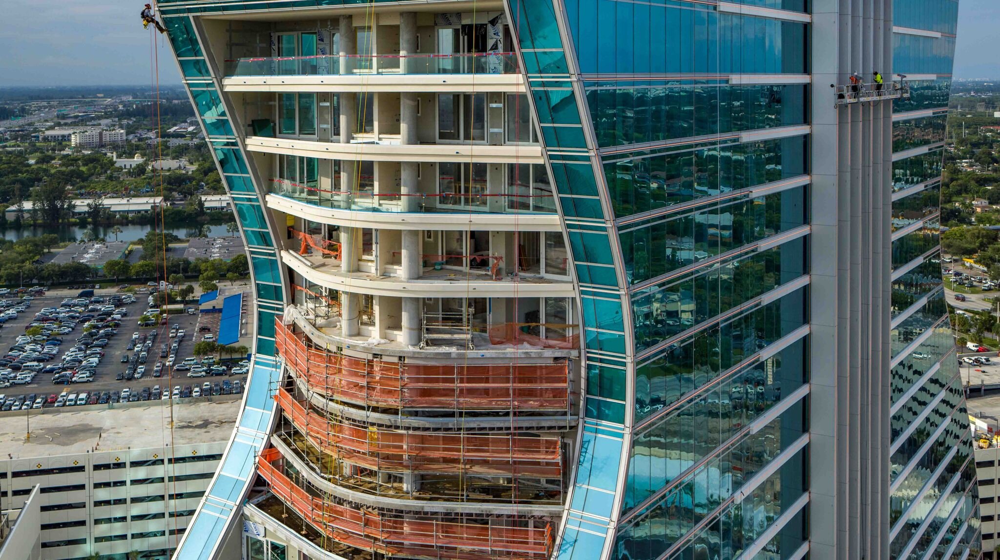
At Drone Genius, we provide systematic aerial documentation for large-scale construction projects that demand precision, consistency, and professional-grade deliverables. Our construction documentation services go beyond basic progress photos—we deliver strategic visual assets that support stakeholder communication, timeline accountability, marketing pre-sales, and project completion storytelling.
With over a decade of experience documenting South Florida's most ambitious development projects, we understand the unique needs of general contractors, developers, and project managers overseeing complex, multi-phase construction. From groundbreaking to ribbon cutting, we become an extension of your project team—providing reliable, weather-flexible aerial documentation that keeps your stakeholders informed and your marketing ahead of schedule.
Our Construction Documentation Services
Multi-Phase Progress Documentation
Large-scale construction projects require systematic documentation that tracks progress over months or years. Our phased approach ensures consistent coverage from predictable camera angles, enabling powerful before/after comparisons and time-lapse compilations that tell the complete story of your project.
Monthly or Quarterly Documentation Flights:
Pre-planned flight paths with consistent camera angles
High-resolution aerial photography capturing overall site progress
Detail shots of critical construction phases and milestones
Weather-flexible scheduling with rapid rescheduling capability
Cloud-based delivery with organized file naming and version control
Delivered Assets:
8K aerial photography suitable for large-format printing
4K video walkthroughs of site progress
Annotated comparison images highlighting month-over-month changes
Organized photo libraries with date-stamped metadata
Project summary reports with aerial imagery
Why Developers Choose Phased Documentation:
Consistent aerial documentation provides objective visual records that support project management, investor updates, dispute resolution, and post-project marketing. Our clients use phased documentation for:
Investor & Owner Updates: Visual proof of construction milestones and budget allocation
Timeline Accountability: Objective evidence of on-schedule progress or delay documentation
Subcontractor Coordination: Site-wide visibility for trade scheduling and logistics
Marketing Pre-Sales: Compelling progress imagery for pre-construction sales efforts
Project Closeout: Comprehensive visual record from start to finish


Construction Progress Storytelling & Time-Lapse
Transform months of construction into compelling visual narratives. Our time-lapse services combine periodic aerial documentation with edited sequences that showcase your project's evolution—ideal for marketing, investor presentations, and celebrating project milestones.
Time-Lapse Capabilities:
Hyperlapse Video Sequences: Edited compilations of monthly flights showing dramatic project transformation
Annual Progress Videos: 60-90 second highlight films showcasing a year of construction in cinematic format
Side-by-Side Comparisons: Split-screen before/after sequences demonstrating construction phases
Milestone Celebration Videos: Dramatic reveals for groundbreaking, topping-out, and grand opening events
Creative Storytelling Applications:
Pre-sales center video loops showcasing project progress
Social media content highlighting construction milestones
Investor roadshow presentations with compelling visual evidence
Community engagement showing neighborhood transformation
Award submissions and industry recognition materials

Stakeholder Communication & Progress Reporting
Construction projects involve complex stakeholder relationships—owners, investors, lenders, city agencies, and community groups all require regular communication. Our aerial documentation services provide the visual clarity that facilitates transparent, professional stakeholder engagement.
Stakeholder Communication Materials:
Investor Presentation Decks: High-resolution aerials formatted for PowerPoint/Keynote
Lender Progress Reports: Objective visual documentation supporting draw requests
City Agency Coordination: Aerial documentation for permitting and inspection processes
Community Updates: Accessible aerial imagery for neighborhood meetings and public relations
Board Presentations: Executive-level visual summaries for ownership and investment committees
ROI of Transparent Communication:
Clear, consistent aerial documentation reduces stakeholder anxiety, minimizes status update meetings, and provides objective evidence of progress—ultimately saving project leadership time and maintaining stakeholder confidence throughout the construction process.

Large-Scale Site Surveys & Planning
Before breaking ground, comprehensive site documentation establishes baseline conditions and supports design refinement, permitting, and logistics planning. Our pre-construction site surveys deliver the aerial intelligence your team needs to plan effectively.
Pre-Construction Surveying:
High-resolution orthomosaic mapping for site planning
Topographic elevation data and grading analysis
Access point and staging area assessment
Neighboring property context and impact analysis
Environmental baseline documentation
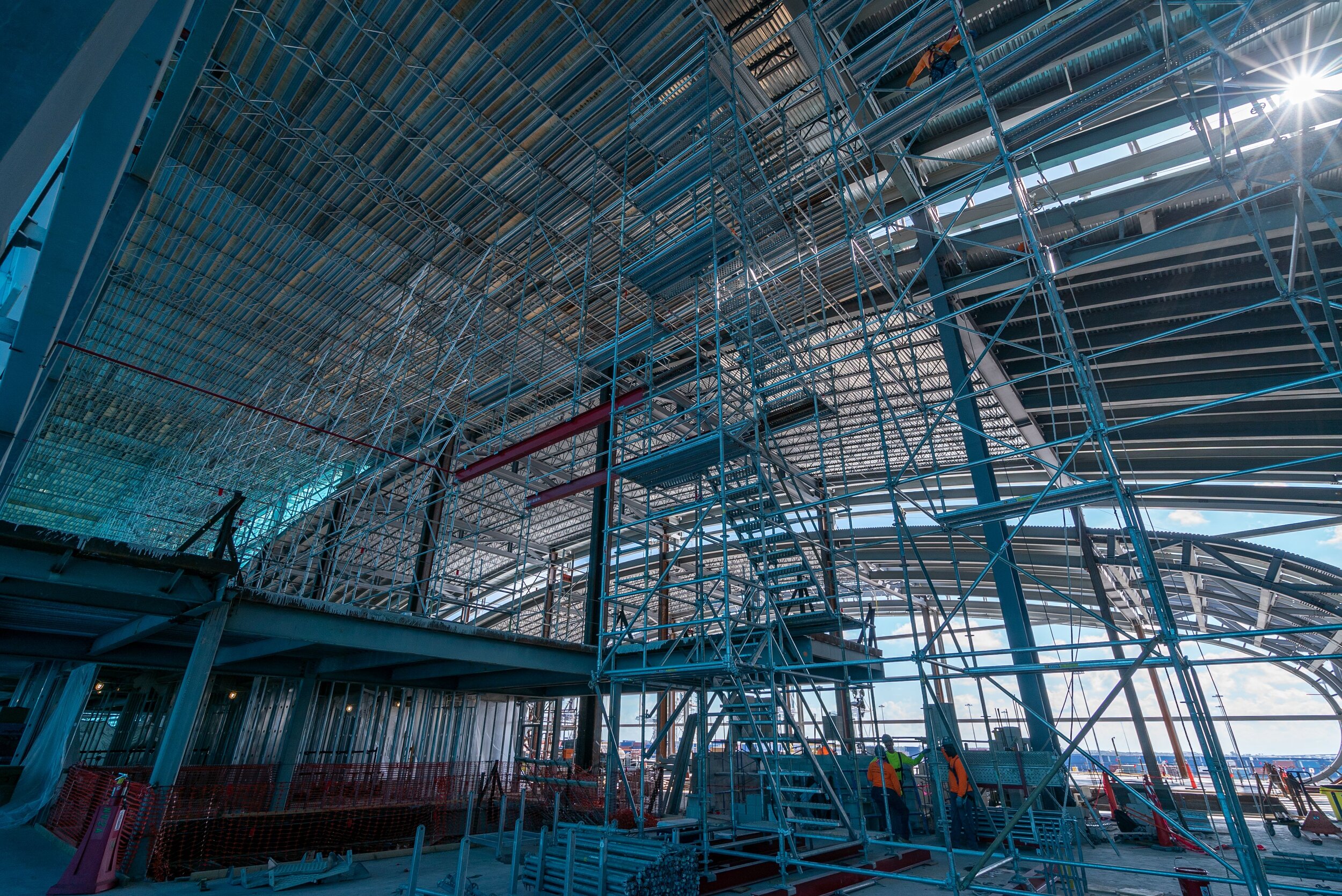
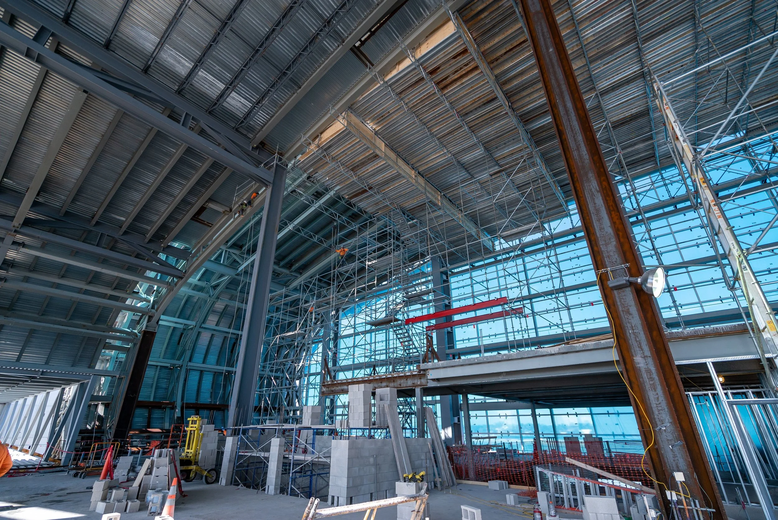
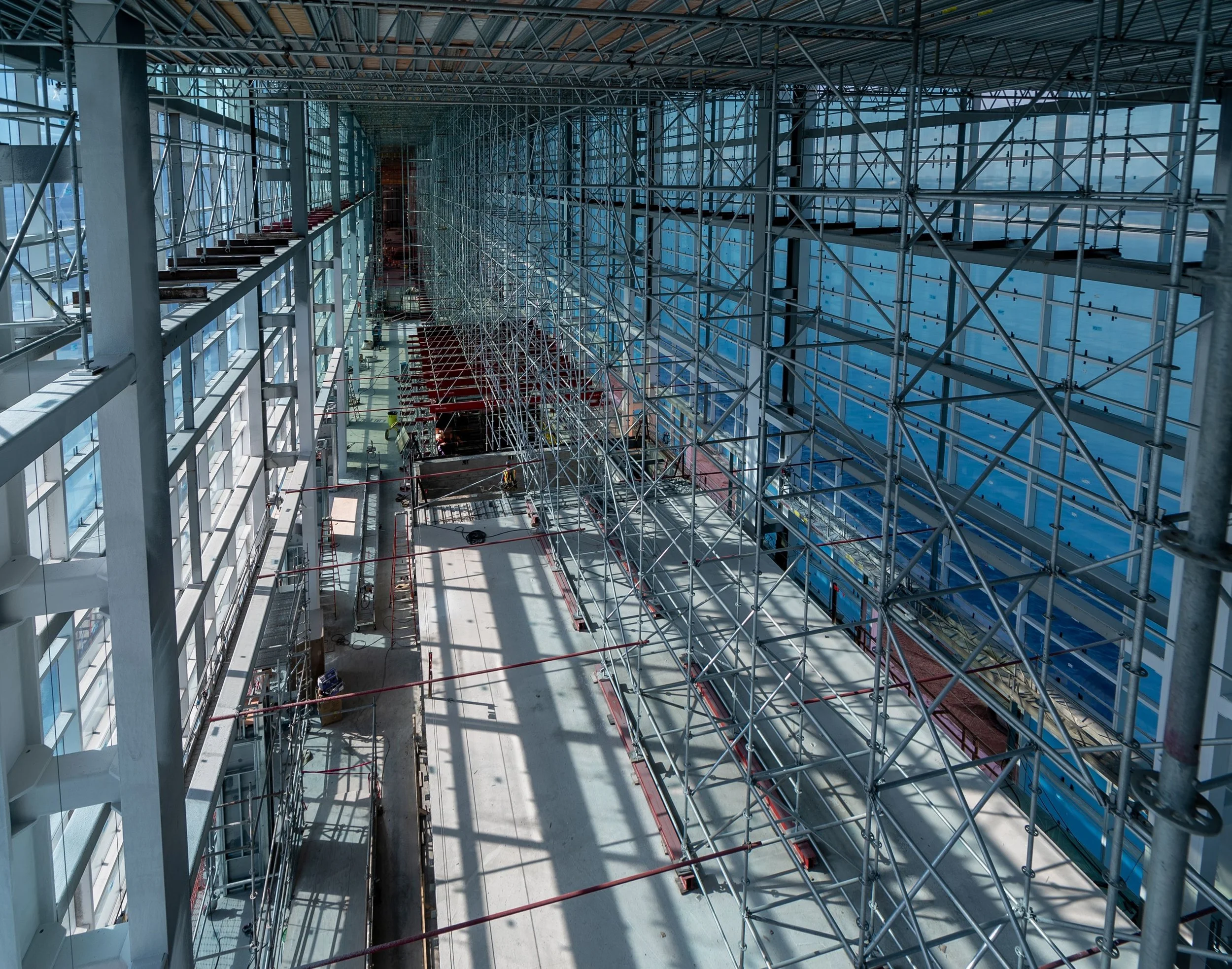
Construction Phase Site Surveys:
Earthwork volume calculations for cut/fill verification
Foundation and structural progress verification
MEP and facade installation documentation
Site logistics and equipment placement overview
Safety and compliance documentation


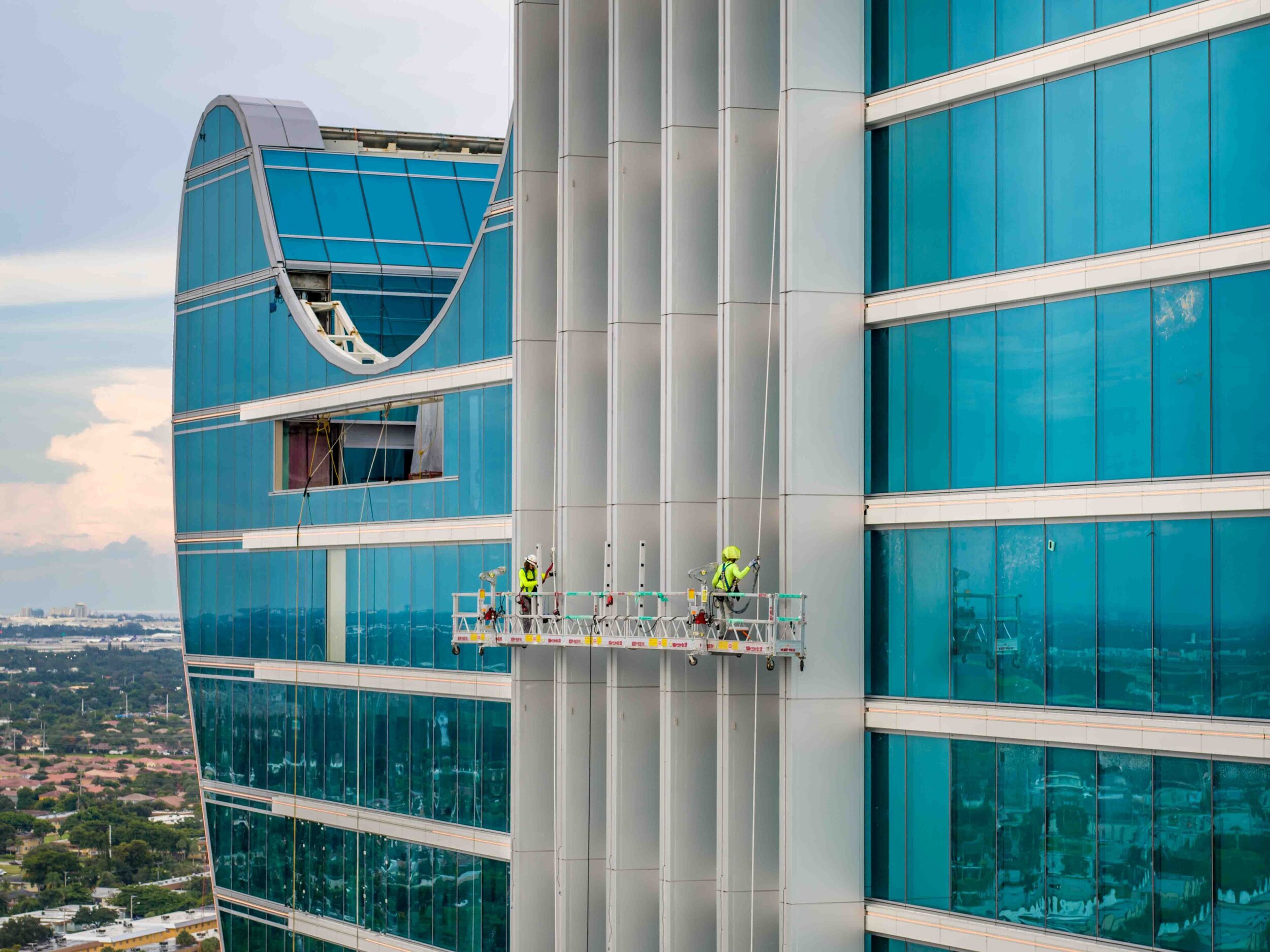
Construction Site Safety & Compliance Documentation
Aerial documentation provides objective evidence of site conditions, safety protocols, and regulatory compliance—critical for OSHA requirements, insurance documentation, and dispute resolution.
Safety & Compliance Applications:
Site-wide safety protocol documentation
Fall protection and scaffolding installation verification
Equipment placement and load zone documentation
Storm damage assessment and insurance claims support
Pre- and post-inspection documentation for regulatory agencies

Why Contractors & Developers Choose Drone Genius
✓ Decade of Florida Construction Experience
We've documented hundreds of South Florida construction projects—from high-rise condominiums to mixed-use developments, industrial facilities, and infrastructure projects. We understand construction timelines, site logistics, and contractor communication.
✓ Weather-Flexible Scheduling
Florida weather is unpredictable. We maintain flexible scheduling with rapid rescheduling capability, ensuring your documentation flights happen on time without disrupting your project schedule.
✓ Consistent, Professional Deliverables
We deliver organized, professionally edited imagery on predictable schedules. Your project team receives cloud-based access to properly named files with metadata—no more hunting through email attachments.
✓ Airspace & Permitting Expertise
Many South Florida construction sites operate in controlled airspace. We handle all FAA authorizations, LAANC coordination, and city permitting—keeping your documentation on schedule without regulatory delays.
✓ Scalable Service Levels
Whether you need quarterly progress documentation for a $10M project or weekly flights for a $100M+ development, we scale our services to match your project scope and budget.
✓ Fully Insured & Job Site Ready
We carry $5M aviation liability insurance (expandable to $10M) and understand construction site safety protocols. Our pilots coordinate with site superintendents and follow your site-specific safety requirements.
Technical Specifications & Deliverables
Equipment & Capabilities
Primary Platform: DJI Inspire 3
8K CinemaDNG and ProRes 422HQ video recording
44MP DNG RAW still photography
14+ stops of dynamic range for challenging lighting
28-minute flight time covering large construction sites
Dual-operator capability for precision documentation
Supplemental Platforms:
DJI Mavic 3 Cine: Compact platform for constrained urban sites, 46-minute flight time
Sony Airpeak S1: Full-frame camera integration for maximum image quality
Deliverables Include:
High-resolution JPEG and RAW photography
4K/8K video footage as specified
Organized file libraries with date and location metadata
Cloud-based delivery with secure client access
Optional: Annotated comparison images, progress reports, time-lapse edits
Our Construction Documentation Process
1. Project Kickoff & Planning
We begin with a comprehensive project consultation to understand your documentation goals, stakeholder requirements, and project timeline. We establish:
Documentation frequency (monthly, bi-weekly, weekly)
Specific camera angles and shot list requirements
Deliverable formats and delivery schedule
Point of contact for scheduling and coordination
Weather contingency and rescheduling protocols
2. Baseline Documentation Flight
Our initial flight establishes baseline conditions and confirms camera angles. We capture comprehensive site documentation before construction begins, providing the reference point for all future progress documentation.
3. Ongoing Progress Flights
Scheduled flights occur on predictable intervals throughout your construction timeline. Our team coordinates with your project superintendent to ensure optimal timing and site access. Each flight delivers:
Consistent camera angles matching previous documentation
Comprehensive site coverage from multiple perspectives
Detail shots of current phase construction activities
Organized deliverables via cloud-based transfer
4. Time-Lapse & Storytelling (Optional)
At project milestones or completion, we compile months of documentation into compelling time-lapse sequences and storytelling videos that showcase your project's transformation.
Case Study Examples
18-Month High-Rise Condominium Documentation (Miami Beach)
Monthly aerial documentation of luxury residential tower from foundation through completion. Deliverables included 200+ high-resolution aerials, quarterly progress reports, and final time-lapse video used for sales center marketing and developer portfolio.
Large-Scale Mixed-Use Development (Fort Lauderdale)
Bi-weekly documentation flights over 24-month construction timeline. Provided investor presentation materials, lender progress reports, and social media content highlighting construction milestones. Final time-lapse sequence delivered for grand opening celebration.
Commercial Office Complex (Boca Raton)
Quarterly documentation and time-lapse video for multi-building office campus. Aerial documentation supported tenant pre-leasing marketing and provided ownership with executive-level progress visibility throughout construction.
Pricing & Project Engagement
Our construction documentation services are structured around project timelines and documentation frequency. We offer:
Monthly Documentation Plans:
Starting at competitive rates for routine progress flights with consistent deliverables
Comprehensive Documentation Programs:
Multi-year commitments with discounted per-flight pricing, priority scheduling, and dedicated account management
Custom Project Solutions:
Tailored documentation programs matching your specific project requirements, stakeholder needs, and budget parameters
Contact us for a customized proposal based on your project scope, timeline, and documentation goals.
Let's Document Your Project
From groundbreaking to grand opening, we deliver the aerial documentation that keeps your stakeholders informed, your marketing ahead of schedule, and your project visually documented at the highest professional standard.
Contact Drone Genius:
Construction Expertise: 10+ years documenting South Florida developments
FAA Certified: Part 107 Licensed & Fully Insured ($5M-$10M)
Weather-Flexible: Rapid rescheduling for Florida's unpredictable weather
Typical Response Time: Same-day project consultations
Turnaround: 48-72 hours for deliverables
Technical Deliverables Include:
8K Aerial Photography (RAW + JPEG)
4K/8K Video Documentation
Time-Lapse & Hyperlapse Sequences
Progress Comparison Images
Cloud-Based Delivery & Organization
Optional: Orthomosaic Mapping & Volumetric Analysis
Serving:
General Contractors | Developers | Project Managers | Construction Managers | Civil Engineers | Architects | Real Estate Investment Firms | Lenders & Financial Institutions